
How to Read a WPA Veterans’ Grave Plat, and the Card Filed Behind It
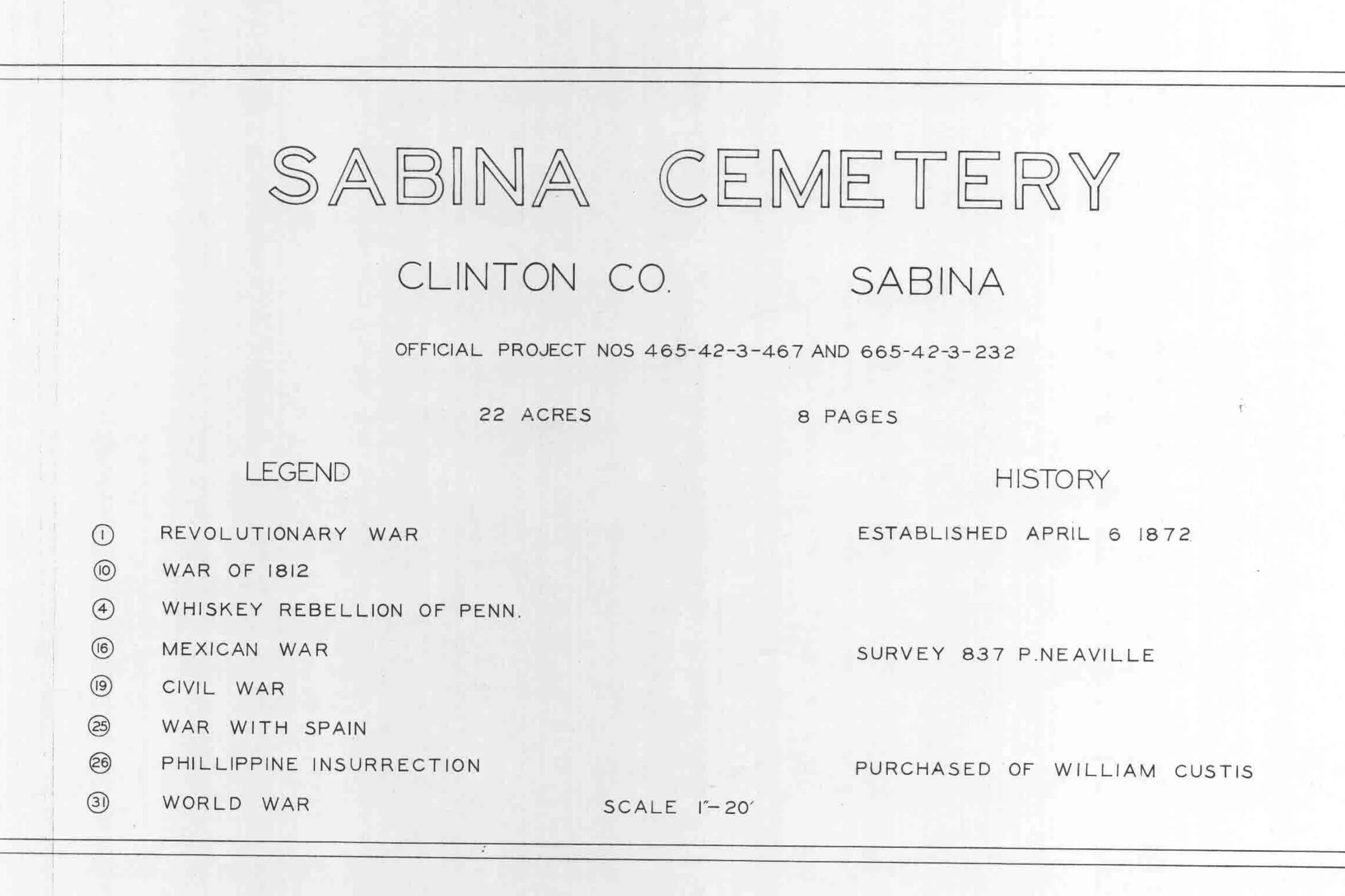
Works Progress Administration (WPA) Veterans’ Graves Registration plat, Sabina Cemetery, Richland Township, Clinton County, Ohio, 1938–1940, Page 56. Scan: Clinton County Engineer’s GIS website.
The first thing I do with a WPA cemetery plat is turn it. I carry the printed sheet into the cemetery and rotate it until the map’s north arrow points to real north. On these sheets north is not always at the top of the page. On the Sabina Cemetery section map, it points toward the upper-left corner. Skip that step, and every row you count runs the wrong way.
These maps are among the most useful tools I have found for Clinton County’s cemeteries, and among the least known. You do not need any research experience to use one. This post walks through a single cemetery, one page at a time.
What the Plats Are
On October 15, 1938, the Daily News-Journal of Wilmington, Ohio, reported that twelve men had started work on “a record of the graves of soldiers buried in Clinton County cemeteries.” The project was a partnership of the Works Progress Administration, the New Deal agency that put unemployed Americans to work, with the state adjutant general and the American Legion. The crew began in Sugar Grove Cemetery in Wilmington and branched out from there.
The work produced two records meant to be used together. The first is a book of cemetery plats, drawn to scale, that marks where each veteran lies. The second is a card for each veteran, recording what the crew could learn about his service. Clinton County’s plats carry two official project numbers, 465-42-3-467 and 665-42-3-232, and the county set runs to more than a hundred pages.
It was painstaking work, done while a great many Americans were struggling to make ends meet. More than eighty years later it is still paying off for anyone looking for a grave.
Both records are still close at hand. The Clinton County plats are posted on the County Engineer’s GIS website. The Clinton County Genealogical Society’s library holds a copied set of the county’s grave registration cards. A state set of the cards is held by the Ohio History Connection as State Archives Series 183, and it can be searched on Fold3.
Reading the Plat, Page by Page
A cemetery’s plats usually run several pages. Sabina Cemetery’s run eight: pages 56 through 63 of the county book.
The title page (page 56). This gives the cemetery’s name, the project numbers, its size (“22 ACRES”), its page count, and a small history box: “ESTABLISHED APRIL 6 1872,” the survey number, and “PURCHASED OF WILLIAM CUSTIS.” It also carries the legend, the key to the whole plat.
The legend. Each veteran’s war is written as a number in a small circle. The legend prints only the numbers used on that cemetery’s sheets. Sabina’s lists eight: 1 Revolutionary War, 10 War of 1812, 4 Whiskey Rebellion of Penn., 16 Mexican War, 19 Civil War, 25 War with Spain, 26 Phillippine Insurrection (spelled that way on the plat), and 31 World War. The numbers skip because they come from a longer master list. I have not found an official copy of that list for Clinton County, so I read each cemetery’s own legend and nothing more.
The section map (page 57). This is the drawing of the grounds. Each section is numbered and labeled with the page that lists its burials. The map also gives a scale (one inch to forty feet), the street along the front (College St.), and the north arrow you will need outside.
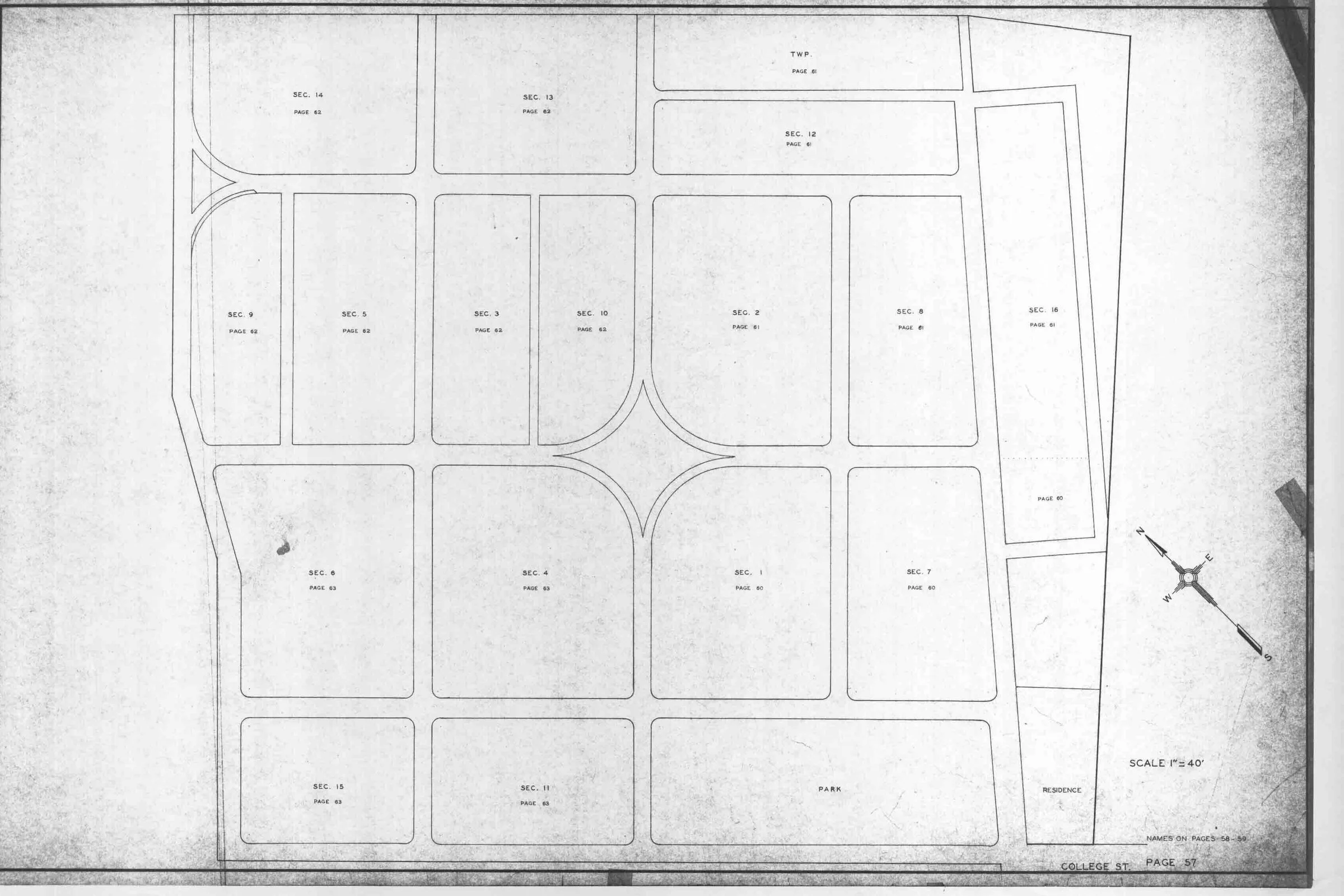
Works Progress Administration (WPA) Veterans’ Graves Registration plat, Sabina Cemetery, Richland Township, Clinton County, Ohio, 1938–1940, Page 57. Scan: Clinton County Engineer’s GIS website.
The name list (pages 58–59). Veterans are listed alphabetically, with columns headed WAR, SEC., LOT and GRAVE. A few rows read “UNKNOWN” where the crew could not place a grave. A few are pointers, not graves: “CURTIS, THOMAS (SEE THOMAS GILL).”
A worked example. On page 59, find “WHITE, JOSHUA.” His row reads: circled 4, Section 5, Lot 3, Grave 8. Back on page 56, the legend turns that 4 into “Whiskey Rebellion of Penn.,” the 1794 tax uprising in western Pennsylvania. Page 57 shows where Section 5 sits on the grounds. Three pages, one answer.
The Card Filed Behind It
Each veteran’s card is a printed form, typed in by the WPA crew. It gives the name, the dates and places of birth and death, the cemetery, the section, lot and grave, the kind of marker (flat, upright or none), and a service record: the war, branch, rank and unit.
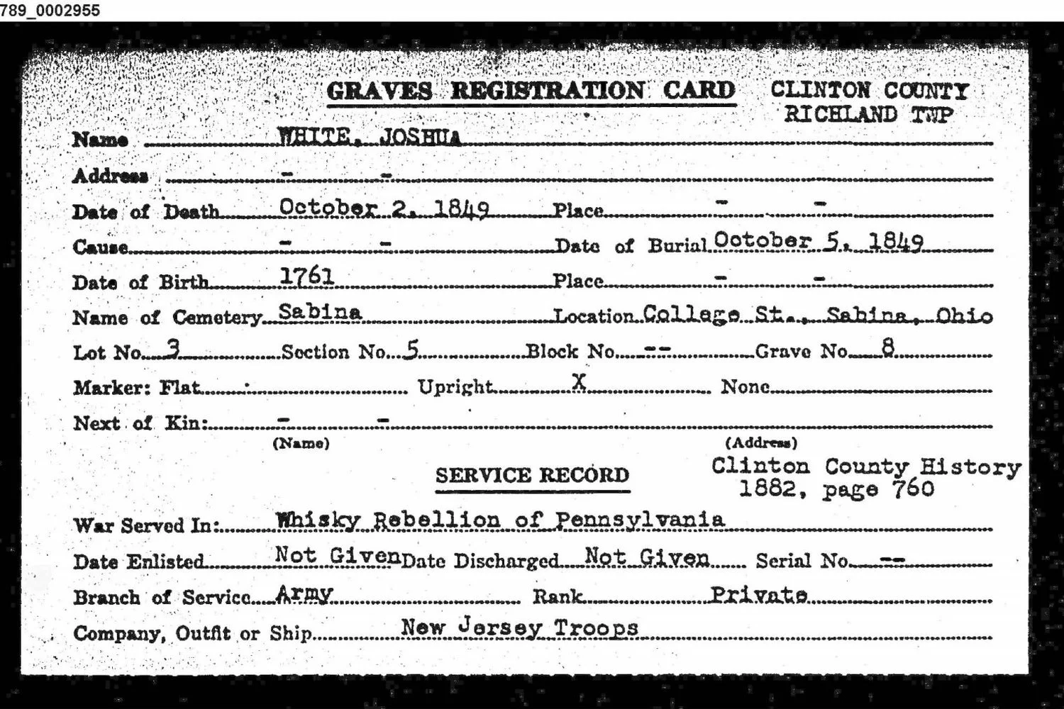
Ohio Soldiers Grave Registration Card (Ohio History Connection, State Archives Series 183; Fold3 frame 182789_0002955). War Served In: Whisky Rebellion of Pennsylvania.
Joshua White’s card agrees with the plat: Sabina, Section 5, Lot 3, Grave 8, an upright marker. It adds what the plat cannot: “Whisky Rebellion of Pennsylvania,” private, “New Jersey Troops,” born 1761, died October 2, 1849.
Don’t skip the line in the upper right of the service record. It tells you where the crew got the service information. For White it reads “Clinton County History 1882, page 760.” That means the card records what an earlier book said. It is a finding aid, not an original service record, and it tells you exactly where to look next.
Some cards are only pointers. One reads “BREWER, JOHN — See Brower, John.” Search every spelling you can think of.
When the Plat and the Card Disagree
They usually agree. When they don’t, the difference is worth writing down, not smoothing over.
In Sugar Grove Cemetery, a father and son share Lot 61 in Section 1. The plat letters Joshua Champlin Sr. with the War of 1812 code at Grave 5, and Joshua Champlin Jr. with the Civil War code at Grave 9. Their cards agree on the section, the lot and the wars, and disagree on the graves: Grave 2 for the father, Grave 1 for the son. Neither record explains the difference.
The online memorials for the two men split the same way: one gives the plat’s grave number, the other the card’s. That is exactly why I record both and note which source said what. In the field, the lot is your anchor. The grave number is a question to settle at the ground.
Researcher Beware: Look at the Whole File
The scanned plats come as files named for a cemetery, and the name does not always tell you everything inside. One file named for Grassy Run Cemetery in Wilson Township, Clinton County, Ohio, holds two facing pages, and they describe two different burial grounds. At first I took them for two views of the same cemetery. The titles on the pages say otherwise.
Grouping small cemeteries that way probably saved the crews time. For researchers it means one thing: open every file and read every title block, because there may be more in your copy than its name suggests.
Taking the Plat Outside
This summer I used the plat for Coulter Cemetery, a small burying ground in Wilson Township, to work out how its graves were laid out. From the 1938 drawing I found the grave of James Spencer. His card calls him a Revolutionary War soldier who later held a captain’s commission in the War of 1812. During the cleanup I marked his grave and others with temporary utility flags.
Knowing that veterans lie in a ground matters beyond the family tree. At Coulter, it helped me make the case to township and county officials that these historic cemeteries deserve protection. Ohio law directs township trustees to “provide for the protection and preservation” of the cemeteries in their care, and allows them to re-erect fallen tombstones (Ohio Revised Code 517.11).
A few practical notes:
- Print the section map and the name page for your cemetery, and bring both.
- Turn the map to true north before you count anything.
- Start from a fixed point on the map, such as the road, the gate or a corner, and count lots from there.
- Expect gaps. Markers fall, sink or disappear. The plat still shows where a grave was recorded in 1938–1940.
One Thing You Can Do
The 1938 story ended with a request. The crew asked the public to tell them about burial grounds they could not find on their own: graves on farms, abandoned churchyards, “out of the way places.”
That request still stands. These grounds belong to all of us, and the best protection they have is people who notice. This is America’s 250th year. I have suggested to local officials that it would be a fitting year to ask for 250 volunteers across Clinton County, a couple for each of our 90-some cemeteries. Each pair would do one thing once a year: visit, note the condition, check the sign and the way in, and report back to the township or county officials who maintain the grounds. Groups like the Clinton County History Center, the Clinton County Genealogical Society and Ohio’s State Historic Preservation Office can help with guidance and, sometimes, grants.
To use a WPA plat and card yourself:
- Find your cemetery’s plats. In Clinton County they are on the County Engineer’s GIS website.
- Read that cemetery’s own legend for the war codes.
- Look up the veteran’s card: the Clinton County Genealogical Society’s library has a copied set of the county’s cards, and the state’s set (Ohio History Connection, Series 183) is searchable on Fold3. Note the card’s source line.
- When the plat and card disagree, write down both and say which is which.
- Take the plat outside, turn it to north, and look.
- Once a year, visit a cemetery near you, and tell the people responsible for it what you see.
Sources: Works Progress Administration, Veterans’ Graves Registration plats, Clinton County, Ohio, 1938–1940 (Official Project Nos. 465-42-3-467 and 665-42-3-232): Sabina Cemetery, pp. 56–59; Sugar Grove Cemetery, p. 67; Coulter Cemetery, p. 20 (scans: Clinton County Engineer’s GIS website). Ohio Soldiers Grave Registration Cards (Ohio History Connection, State Archives Series 183; Fold3 frames 182789_0002955, 182715_0003250, 182715_0003251). “Work Started on Recording Vets’ Graves,” The Daily News-Journal (Wilmington, Ohio), October 15, 1938, p. 8 (Newspapers.com). Ohio Revised Code 517.11.

